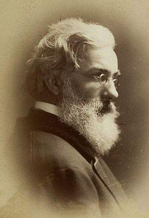
Ernest George Ravenstein
Contents
Notes
Office Notes
AI Council 1900 Member
AI Council 1901 Member
AI Council 1902 Member
House Notes
proposed 1883.06.12
Notes From Elsewhere
Ernst Georg Ravenstein (Ernest George) (30 December 1834 – 13 March 1913) was a German-English geographer cartographer. As a geographer he was less of a traveller than a researcher; his studies led mainly in the direction of cartography and the history of geography.
Ravenstein was born in Frankfurt am Main, Germany, to a family of cartographers. He spent most of his adult life in England in a house at Lorn Road, Lambeth, but he died in Germany, his country of birth, on 13 March 1913.[1]
When he was 18 years old he became a pupil of Dr. August Heinrich Petermann. After moving to England, Ravenstein became a naturalised British Subject and was in the service of the Topographical Department of the British War Office for 20 years, from 1855 to 1875. A long-serving member of the councils of the Royal Statistical and Royal Geographical Societies, he was also Professor of Geography at Bedford College in 1882–83. He was the first to receive the Victoria gold medal of the Royal Geographical Society (1902) for "his efforts during 40 years to introduce scientific methods into the cartography of the United Kingdom".[2]
His geographical statistics and projections were respected and used as a basis for official planning at the time.
...
In 1861 Ravenstein established the German Gymnastics Society, a sporting association, in London. It promoted gymnastics and held annual athletic competitions, at a purpose-built German Gymnasium in St Pancras,[7] and at The Crystal Palace. By 1866, the society had 1,100 members, drawn from more than 30 nationalities, with 650 members being Britons, mostly tradesmen.[8] With William Penny Brookes and John Hulley, he was a founder member of the National Olympian Association in 1866, which promoted an annual series of sporting events across the country, inspired by the Olympic Games of Much Wenlock. He published a handbook on gymnastics in 1867.
Publications
External Publications
Systematic Atlas (1884)
The Philips's World Atlas was published with Ravenstein's plates and statistics for several decades
Map of Equatorial Africa (1884)
Vasco da Gama's First Voyage (1898)
The Russians on the Amur (1861) (Full text can be found on Google Books).
Handy Volume Atlas (1895; seventh edition, 1907)
Martin Behaim. His Life and his Globe (1908) A Life's Work (1908)
The New Census Physical, Pictorial, and Descriptive Atlas of the World (1911)
Philips' Handy-Volume Atlas of the World containing seventy seven New and Specially Engraved Plates with Statistical Notes & Complete Index (Fourteenth edition, revised to date)
History of cartography article for the 1911 Encyclopædia Britannica's "Map" entry.
